snowiest us cities

All posts tagged snowiest us cities

Updated 6/8 -I just want to give a Big Thanks to Michael Yates for your recent donation. Even though we are getting into the warm months, the donations still help out a lot in paying some of the bills ;) Thanks Michael, I really appreciate you taking the time :)
———————————-

Lakewood, Colorado Wins Golden Snow Globe Contest

Congratulations to Lakewood, Colorada for being the officially, unofficial snowiest big city in the United states for the 2015-2016 snow season. Believe it or not, any snow that falls up until June 30th still counts for the 2015-2016 snow season. I feel pretty confident calling the snow contest and the winner right now with Lakewood having over a foot of snow more than Syracuse, New York, and a 20+ inch lead over Fort Collins and Denver Colorado as of this posting. The only reason I waited this long to call it was because of the Colorado cities still having a chance for some snow. I will update the seasonal snow stats as/if needed.

Lakewood,Co received some decent late season snow that dropped more than enough snow to skate past the normal season favorite Syracuse, New York which held the lead a couple times this season. Lakewood also slipped past Erie, Pa, South Bend, Indiana, Flint, Michigan and Sioux Falls which were holding the top 5 spots on or around March 3rd. At that time, Lakewood was in 6th place, 20+ inches behind the leader then, Syracuse, New York.

Even though it was a mild winter for a lot of the cities this season the snow contest was pretty close and exciting once the snow finally did start falling. There were several lead changes throughout the 2015-2016 snow season and what made it fun was that it was a mix of cities on the top or near the top from all over the US. A couple that you wouldn’t expect including Lakewood, CO which as of right now has almost 40 inches of snow above their normal snowfall for the season compared to Syracuse, NY which has a snow deficit of over 40 inches this season. WTG Lakewood :)

How The 2015-2016 Snow Season Started

Anchorage, Alaska started off the 2015-2016 Golden Snow Globe contest when I did an update on September 30th. The National Weather Service was reporting 2.8 inches of snow and was the only city reporting measurable snowfall. A few others were showing just a trace of snow. Syracuse, NY was the next city to report some measurable snow on or around October 18th-19th, 2015.

Finally a Top 10 Snowiest City List

We finally had a Top 5 list for snowiest Big cities in the United States around November 6th and didn’t have a top 10 list until November 17th when there were 12 cities reporting measurable snowfall.  Anchorage, Alaska was still in the lead with 9.6 inches of snow.  Below is pretty much how this season played out as far as cities that led the snow contest at one time or another.  Keep in mind that the National Weather Service updates the snow stats the next day for the previous day so the dates are give or take a day ;)

Lead Changes in The 2015-2016 National Golden Snow Globe Contest

9/30 – Anchorage, Alaska started the 2015-2016 Golden Snow Globe contest on or around September 30th

12/15 – Lakewood, Colorado takes the lead with 24.0 inches of snow. Anchorage is in 2nd with 22.2 inches.

* NOTE – Come Christmas day, Reno, Nevada had 10.5 inches of snowfall.  Reno is beating Erie, Pa which only has 4.8 inches. Rochester, NY has 1.2, Syracuse has 0.8 inches on Christmas day, Buffalo, NY is showing just a tenth of an inch and Worcester, MA is only reporting a trace of snow on the season. WOW! It gets better! Last season’s snow champs, Lowell, MA doesn’t even have a snowflake yet ;)

12/29 – Sioux Falls, South Dakota takes the lead from Lakewood, CO with a snow total of 32.7 inches of snow on the season.

* NOTE – 1/15 – About Halfway through January the snow contest started getting more exciting with the Northeast cities finally starting to get into the snowball fight :)

1/20 – Erie, PA takes the lead from Sioux Falls, SD by two-tenths of an inch posting 42.3 inches. Sioux Falls has 42.1 inches of snow.

1/25 – Sioux Falls started packing the snowballs and took the lead back from Erie, Pa. Syracuse has been hanging in 3rd place just waiting to slide to the top on the snow mountain.

1/29 – Erie, PA takes slips back to the top with leading Sioux Falls by half an inch.

2/2 – While Erie and Sioux Falls were battling it out this season’s snow champs Lakewood, CO slipped past both of them by just over an inch of snow :)

2/10 – At this point in the snow season there was a lot of back and forth going on. Erie, PA slides to the top again!

2/14 – Yayyyy! Syracuse, NY finally climbed to the top of the snow mountain for the first time this season. Yeah, I’m from Syracuse so I can say Yayyyy :P

2/16 – OK, so much for my Yayyyy :( Erie, PA retakes the lead!

3/2 – Buh Bye Erie, Hello Syracuse ;)

3/24 – Lakewood had more than enough time away from the top to make some snowballs and they put them to good use retaking the lead ;)

4/3 – I was surprised that Syracuse got some decent snowfall in April to slip past Lakewood by almost 6 inches of snow come 4/4 and Syracuse was at 80.4 inches on the season. Well below their normal average but hey, seemed like enough. Us folks in Syracuse were pretty much ready to do a victory dance ;)

4/17 – Lakewood gets pounded with snow on or around the 16th and 17 and picks up 16 inches of snow. No, really they did. Can you say snow season and contest over :( Lakewood sleds to the top of the Golden Snow Globe mountain and sets up camp. Ain’t no city gonna touch em after that. 16 inches of snow in April, you deserve to be crowned the snow champs for the snowiest big city in the United States. Way to go Lakewood, Colorado :)

Click here see all of the 2015-2016 snow updates throughout the season!

5/24 – The funny part is that Lakewood and all of the Colorado cities continued to pile up snow after they got hammered by that storm. That was why I was a little hesitant to call the contest. I was waiting to see if Denver or Fort Collins, CO could catch Lakewood. With a 20+ inch lead right now I feel pretty confident that Lakewood will be the snowiest big city in the United States with a population of 100.000 or more. If something changes then the snow contest will go on. That said, Congrats Lakewood and well deserved :)  We had 14 lead changes this season give or take a couple which isn’t too bad considering the lack of snow for a lot of cities.

It Was a Fun National Snow Contest This Season

So, all in all, this season’s national Golden Snow Globe contest for snowiest Big cities in the United States turned out to be a fun snow race and exciting too.  It’s obviously all of you that visit the snow site and our Facebook snow group page that made it so much fun.  A Big Thanks to all of you for helping to make the 2015-2016 snow season a blast.  That also includes all of you news folks out there that wrote about the snow contest and also the Meteorologists who helped out by keeping us informed.

A special Thanks to those of you that were able to donate to the snow site.  The donations help out a lot not to mention always keep me motivated, lol ;)

Hope you all had fun. Feel Free to buy me a cold one ;)


OK, really it helps me pay the bills through the Summer and just maybe a cocktail or two :) !


I’ll still be keeping an eye on the weather and if I hear of a city getting snow I’ll do an update.  Keep in mind that as I mentioned above the snow season according to the National Weather Service runs from July 1st until June 30th. So in other words nothing is official until then ;)

Have a Safe, Nice, Enjoyable Summer All!


What City Was Winning Snow Contest This Time Last Season

I thought it would be fun to compare last season (2014-2015) with this snow season (2015-2016) to see how the cities are doing as we come down the home stretch :) You can compare the cities snow totals to date for both seasons in the chart below. Keep in mind there will be some new cities that were added this snow season just to mix it up and also some cities that were dropped.

I think there are two things that stand out the most. Number one being where the heck is Lowell, Massachusetts and the other MA cities this season? Lowell, MA is the defending National Big city snow champs from the 2014-2015 snow season. You will have to scroll down quite a bit to find Lowell this season as they are currently in 39th place right now. Lowell, MA has 88.7 inches less snow this season compared to last season at this time.

If you remember, last season it was a two-way tie between Worcester, Ma and Syracuse, NY at the end of the season when Mother Nature sneezed and gave Lowell just enough snow to win the Golden Snow Globe snow contest. Or maybe it was an adjustment, wink, wink :P Last season was as close as it could have gotten and was a lot of fun. I’m pretty sure we will have a different snow champ this season, no offense to those of you from Lowell but I don’t think there are enough snow storms left this season to make up 40+ inches of snow.

The second thing that stands out the most is the snow totals or should I say lack of snow totals. This could be the first season since starting the snow contest back in the 2009-2010 season that the winning city may have under 100 inches of snow. Syracuse, NY, the current leader is still almost 30 inches away from 100 inches as of this posting. WOW, what a wimpy snow season for a lot of cities so far. Yes, even though nice weather is taking over I don’t think we are quite done yet ;)

Some Cities Way Below Last Seasons Snow Totals as of 3/6/2016

As always, Keep in mind my fuzzy math ;)

Lowell, MA – Minus 88.7 Inches
Worcester, MA – Minus 83.9 Inches
Boston, MA – Minus 79.8 Inches
Buffalo, NY – Minus 60.8 Inches
Rochester, NY – Minus 59.7 Inches
Providence, RI – 54.1 Inches
Syracuse, NY – Minus 42 Inches
Erie, PA – Minus – 35.5 Inches

And the list goes on as you will see below. There are several cities that are doing a bit better than last season as you will also see below but nothing to really brag about. This season’s snow leaders are on the left and last season’s leaders on the right.

Compare This Snow Season To Last Season

Some of the Top 25 Snowiest
Cities in the United States 2015-2016 Snow Season Updated 3/7/2016

Snowiest City on 3/7

US States
 and Cities

2015 – 2016
Snowfall Totals

Snowiest City 3/7/2015

2014 – 2015
Snowfall Totals

1 Syracuse, New York

72.2

Worcester, Mass

115.6

2 Erie, Pennsylvania

68.3

Syracuse, New York

114.2

3 South Bend, Indiana

66.1

 Lowell, MA

113.6

4 Flint, Michigan

61.6

Buffalo, New York

108.8

5 Sioux Falls, South Dakota

56.6

Boston, Mass

105.7

6 Lakewood, Colorado

53.6

Erie, Pennsylvania

103.8

7 Rochester, New York

53.5

Rochester, New York

95.1

8 Grand Rapids, Michigan

51.7

South Bend, Indiana

79.4

9 Ann Arbor, Michigan

50.5

Grand Rapids, Michigan

77.9

10 Buffalo, New York

48.0

Providence, Rhode Island

73.5

11 Fort Collins, Colorado

45.9

Lakewood, Colorado

70.0

12 Lansing, Michigan

42.5

Cleveland, Ohio

65.9

13 New York, New York (JFK)

40.9

Hartford, Connecticut

59.3

14 Denver, Colorado

38.8

Akron, Ohio

58.8

15 Green Bay, Wisconsin

37.5

Ann Arbor, Michigan

51.3

16 Allentown, Pennsylvania

36.2

Bridgeport, Connecticut

51.3

17 Newark, New Jersey

36.2

Detroit, Michigan

47.5

18 Rochester, Minnesota

35.4

Denver, Colorado

47.5

19 Baltimore, Maryland

35.1

Billings, Montana

47.2

20 Detroit, Michigan

34.0

Pittsburgh,
Pa

45.4

21 Spokane, Washington

33.6

Colorado Springs, Colorado

44.8

22 Milwaukee, Wisconsin

33.3

Toledo, Ohio

44.6

23 Worcester, Mass

31.7

Chicago, Illinois

44.3

24 Salt Lake City, Utah

31.6

Flint, Michigan

43.9

25 Minneapolis, Minnesota

31.2

Allentown, Pennsylvania

43.6

Some of The Other Snowy
Cities in The United States

26 Chicago, Illinois

30.1

New York, New York (Central
Park)

42.5

27 Des Moines, Iowa

30.0

Newark, New Jersey

42.5

28 Anchorage, Alaska

29.3

Milwaukee, Wisconsin

41.5

29 Madison, Wisconsin

28.0

Fort Wayne, Indiana

40.1

30 Omaha, Nebraska

27.4

Rochester, Minnesota

38.3

31 Philadelphia, Pa

27.2

Fort Collins, Colorado

38.2

32 Colorado Springs, Colorado

27.1

Lansing, Michigan

35.6

33 Provo, Utah

27.0

Sioux Falls, South Dakota

31.9

34 Pittsburgh,
Pa

26.1

Rockford, Illinois

30.4

35 Boston, Mass

25.9

Madison, Wisconsin

30.3

36 Bridgeport, Connecticut

25.2

Green Bay, Wisconsin

29.9

37 Akron, Ohio

25.1

Cincinnati, Ohio

29.9

38 Cleveland, Ohio

25.0

Des Moines, Iowa

29.1

39

 Lowell, MA

24.9

Minneapolis, Minnesota

27.2

40 Fargo, North Dakota

24.7

Peoria, Illinois

27.0

41 Billings, Montana

24.4

Philadelphia, Pa

23.0

42 Pueblo, Colorado

24.2

Anchorage, Alaska

20.7

43 Reno, Nevada

24.1

Spokane, Washington

16.6

44 Manchester, New Hampshire

23.0

Provo, Utah

10.1

45 Rockford, Illinois

23.0

46 Washington DC
(National)

22.2

47 Lincoln, Nebraska

20.5

48 Providence, Rhode Island

19.4

49 Fort Wayne, Indiana

19.0

50 Toledo, Ohio

17.7

51 Columbus, Ohio

16.8

52 Peoria, Illinois

15.3

53 Lubbock, Texas

13.3

54 Indianapolis, Indiana

13.3

55 Albuquerque, New Mexico

9.8

Have an Awesome Day Everyone :)

Updated 2/10 7:00 PM – Erie marches back to the Top of the snow mountain into the number 1 spot. Congrats Erie, for now anyways ;)

I figured it was going to be kind of close looking at some snow stats a little earlier. I had a feeling Erie was going to get enough snow this morning and today to take the lead away from Lakewood, CO. The only thing I was concerned about was that I saw that Sioux Falls, SD was getting some snow and thought they may have had a shot at regaining the lead also in the snow contest ;)

Stay Tuned and it will be interesting as to which city will come out on top come tomorrow ;)

Click Here for The Newest Snow Update!
———————————————

National Snowiest Big City In United States Contest

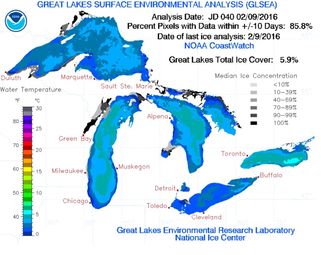
The Golden Snow Globe contest has really been starting to take shape the last week or two with many cities getting enough snow to have a shot at being the King of the Snow Mountain. The good news is that all of the Great Lakes are pretty much wide open which means Lake Effect snow for everyone :) Whether we like it or not there is still a lot of snow season left. Yeah, I know, be quiet huh ;)

With the Great Lakes having little ice on them compared to an average winter season this is a good chance for some of the cities further down the list to start their comeback. Cities like Buffalo, NY have a good chance to move up quite a bit this week and I am guessing they will… And where is Rochester, NY this season and a few others. It’s time to join the snowball fight and have some fun :)

Great Lakes Ice Cover 2/9/2016

Erie, PA which was the King of the snow mountain not too long ago picked up just enough snow to climb their way into the number 3 spot yesterday. Snow is in the forecast for the next several days for a lot of the Golden Snow Globe cities and it will be interesting to see if/when we have a new King of the mountain. I’m guessing sooner rather than later.

Lakewood, Colorado still holds the lead in the National snow contest for Big cities (population of 100,000+) but only by 1.7 inches over second place Sioux Falls, South Dakota. Erie, PA is in 3rd, Fort Collins, CO is in a tie for 4th place right now with Syracuse, New York.

Several of the cities along the great lakes are under lake effect snow watches or warnings now. With the Artic air that is expected to move into the Northeast and other places in the US no doubt, some decent snow will be falling the next several days. It’s going to be fun watching the cities slip and slide up and down the snow mountain :)

A lot of us have been paying attention to the cities around Lake Ontario and Lake Erie but I think it’s time to keep an eye on a couple of the cities around Lake Michigan which is still wide open. South Bend, Indiana and Flint, Michigan come to mind and both cities broke into the Top 10 this last update. I was checking out the radar a little while ago and it looks like Lake Michigan’s lake effect snow machines are cranking out snow in full force right now.

Stay Tuned and Stay Safe All. As always, if You See Snow – Drive Slow! Have a great day ;)

The Massettchusetts cities, Worcester, Boston and Lowell finally got some decent snow and Worcester was able to finally break into the Top 25 snowiest cities.

On a side note (Shameless Plug) – The semi-annual fundraiser (actually the first ever) is going on for the snow site(s) right now. In other words, if you have a couple of bucks or if you’re Bill Gates a few million to donate to help out the snow site (Me), now is a pretty good time. If you don’t, no problem because I don’t either. If so, you do not have to join PayPal in order to donate to the site and all of your info is between you and PayPal other than your name so I know who donated and I can Thank You. Yeah, I know this post is lame but kind of necessary right now. Go Northeast and it’s gonna be fun from here on!

* Thank You Jennifer M. for your donation and for taking the time. They help out a lot Jennifer and I really do appreciate it :)
* Thanks Debra A. for taking the time. I truly appreciate it :)
* I want to give a Big Thanks to John A. for your donation tonight. It helps out more than you know John :)
* Thanks Stephen S. for your donation today. Words even above can’t explain how much it helps me out :)
————————————

Updated 1/21 2:00 AM -Erie, PA is the new King of the snow mountain right now. As of the last update Erie, PA has taken the top spot away from Sioux Falls, SD by one snowflake. Keep in mind that I only updated the Top 5 cities after getting a heads up from Erie’s very own Geoff Cornish. Thanks Geoff for the heads up and making me stay up a little later, j/k ;) Check out the news and Geoffs forecasts for Erie at

Stay Tuned for full update sometime tomorrow when I wake up. Don’t hold your breath for a morning update ;)

———————————————–

Updated 1/20 8 PM -Syracuse, NY has managed to get just enough snowflakes to slip past Erie, PA and to move onto the 2 slot of the snow mountain. Sioux Falls still is the King of the snow mounatin right now by a couple of inches give or take.

I’m loving the way the snow contest has been taking shape this past week and loving how close it is. Some of the other cities that we are use to seeing on the top have been steadily climbing their way to the top. The storm that is expected to hit the coast this weekend should make it even more interesting and fun.

Fun is what the snow contest is all about folks. So have fun and Please take this storm seriously if it’s in the forecast for your area. Have a Great Night and Drive Safe :)

———————————————–

Updated 1/19 8 PM - The snow race is getting exciting and the big question as we all waited for this last update is did Erie take the lead? Better yet did Erie manage to stay in 2nd place?

The answer can be found on the Top 25 page :P Just to give you a heads up before you go there I have to mention that Syracuse broke a date record today breaking the old record of 7.3 inches set back in 2003 and no I’m not saying how much yet No doubt the Golden Snow Globe bears are chasing Syracuse’s butts too ;)

——————————————–

The way Erie, Pennsylvania has been sledding up the snow mountain you would think they are being chased by a Golden Snow Globe snow bear or something. Is there a such thing as a snow bear and do we have them on the mountain? Maybe it’s not a snow bear and it’s Syracuse, New York they are trying to stay ahead of. Both cities have been climbing towards the top of the National snow contest for Big cities with a population of 100,000 or more.

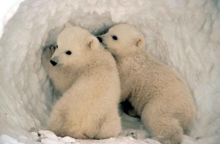
Cute little polar bear cubs in the snow.

Both Erie, PA and Syracuse have been able to connect with some decent Lake Effect snow this last week or so moving into the Top 5 of the snowiest BIG cities in the country. The new Top 5 as of this last update are now Sioux Falls, SD, Erie, PA, Lakewood, CO, Spokane, WA and Syracuse, NY. Many other cities have also been breaking camp finally and making the trek to the top of the snow mountain now that the cold air is finally sticking around.

In the last week give or take a day Erie has gone from the 14th slot in the snowiest city contest to the number 2 slot. It will be interesting come the next update to see if Erie can take away the top spot from Sioux Falls. Stay tuned ;)

Syracuse has moved all the way up the snow mountain from the 41st spot to move into the number 5 slot the last several days. Like Erie and several other cities, they hooked into some decent lake effect snow the last week give or take.

The last 7 days have helped several cities in the North East catch up either a little or a lot and the snow contest is finally starting to take shape. Oh, it gets even better maybe for those of you who remember how last season’s snow race went. It went right down to the finish with Lowell, MA pulling out a victory at the very end beating Syracuse and Worcester, MA which were in a tie.

As of this last update last season’s snow champs Lowell are in 47th place give or take with just 6.3 inches of snow so far for the 2015-2016 snow season. Boston isn’t even in the Top 50 right now. The thing is and I’m guessing, most of the cities from the north that are near the bottom right now probably were last season also at this time but then… Then all of the Nor’Easter’s and storms started hitting. Pretty close to right about this time in the season.

Hmmm, did someone say storm? They did and I see all of the pros talking about a storm getting ready to hit some of those cities in the near future that have been hanging at the bottom of the snow mountain. Cities like Boston, Philly and many others. You all know that I am clueless so check with your favorite Meteorologist to get more information on what they are expecting to be a Nor’Easter hitting the coast sometime come Friday and Saturday. Hey, Have a Great Day Everyone ;)

The national Golden Snow Globe contest for snowiest big cities is getting even more interesting now that some of the Northeast cities have come out to play. Sioux Falls, SD has been leading the snow contest for awhile now but some cold air has finally hit most of the North East.

For most of the 2015-2016 snow season, it’s been the cities in the Western United states and Mid US hanging near the top of the Golden Snow Globe mountain. The last several days the artci air has finally moved into the eastern have of the US bringing some decent snowfall to some of the cities that are normally camped out by now on top of the snow mountain.

Cities like Syracuse and Buffalo, NY, Erie, PA and Grand Rapids, MI have been camping at the bottom of the snow mountain up until the last few days. Most of those cities weren’t even in the top 30 just a couple of days ago. With the cold air moving in over the warmer than normal Great Lakes the Lake Effect Machines finally started to crank out some snow for the cities near the lakes.

The cities from MAssachuesettes seem to be staying out of the snowball fights so far this season though :( Last seasons snow champ Lowell, MA wasn’t even in the Top 50 as of the last update. Come on out and play Boston, Worcester and Lowell. You’ll have fun. Don’t count them out yet because I’m pretty sure that the snow storms that hit that neck of the woods last season didn’t start for at least another week or so. Plenty of time for them to play catch-up :)

No doubt this is going to be a fun snow contest now that most of the cities have come out to play in the snow. It will be interesting to see if the cities to the northeast can play catch up now. I’m pretty sure they are going to keep getting the snow for awhile but chances are so are the cities at the top.

It’s been a little quiet snow-wise in Sioux Falls the last week or so but Anchorage, Alaska just started adding new snow totals again, the Colorado cities seem to be adding a little every now and then and go figure, even some of the cities in Texas keep adding a little snowfall to their snow totals..

Lake Michigan has been cranking out some decent snowfall for the cities that rely on lake effect from that lake which I am guessing is still warmer than it normally is this time along with the other Great Lakes so stay tuned for a fun snow filled 2-3 months ahead.

Have a Great Day Everyone and as always, See Snow – Drive Slow ;)

Buffalo Breaks No Snow Record

Wow and Congrats to Buffalo on breaking the all-time record for not receiving any measurable snowfall this far into the snow season according the Buffalo National Weather Service.

Buffalo National Weather Service Statement - “It’s official, Buffalo has set a new record for the latest measurable snow. The previous record was December 3rd, set back in 1899. We will continue to add to this record for many days to come, with no cold or snow expected for at least the next 10 days. Here is the 6-10 day forecast, showing very high chances for above normal temperatures to last for much of the nation through the middle of December.”.

So while Anchorage, Alaska has been camping out at the top of the Golden Snow Globe mountain for quite awhile now Buffalo hasn’t even stepped on the snow mountain to start climbing. When Buffalo does finally start climbing the snow mountain they will have at least 46 other cities that are ahead of them to slip past. That’s going to be a whole lot of snowball fights so Buffalo better start stocking up on snowballs. Oh, that’s right they have no snow, lol :)

I did an update earlier today and the top cities continue to add a little snow here and there. A lot of cities are going to have to make up a lot of snow to catch up to the cities near the top of the snow mountain.

Anchorage, Alaska Snowiest Big City in US

Anchorage has been hanging at the top so long now that they probably have a nice snow fort built by now along with an endless supply of snowballs to toss at any city that attempts to take over the top of the mountain. Sioux Falls, South Dakota and Lakewood, Colorado have been keeping close to Anchorage and it will be interesting to see if either of those cities can take over the number one spot on the mountain.

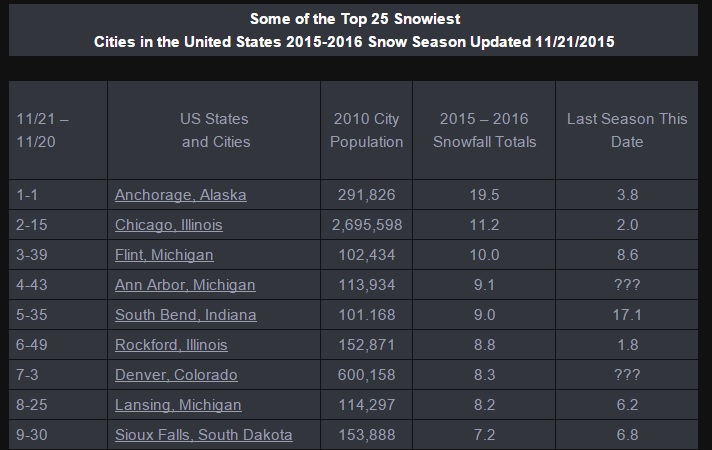
Chicago, Illinois is in 4th place right now. Seriously and I kid you not. Chicago, as of the last update has over a foot of snow already this season. Chicago’s normal snow totals for this time in the season are just around 2 inches of snow. WTG Chicago! Lakewood, Colorado has 16 inches so far for the 2015-2016 snow season which is right around their normals for this time.

It may not be snowing in your neck of the woods but a lot of cities are getting snow. So far and I’m sure there are a few that we missed, 46 Big cities with a population of 100,000 or more have had measurable snowfall so far for the 2015-2016 snow season. Stay Tuned ;)

Have a Great Night Everyone!

First as always, a Big Thanks to Sue B. for your kind donation to the site. They help out a ton to offset costs. It’s also the 1st donation of the new 2015-2016 snow season :) Thanks Sue, much appreciated!
—————————————————

Chicago 2nd in Snowiest Big City Contest – Snow Records Broken

Congrats to Chicago, Illinois on taking over the nuber 2 spot on the snow mountain. Chicago broke a couple of date records for total snowfall the last couple of days and slipped past several cities to take over 2nd place in the Golden SNow Globe national snow contest for Big cities. Several other cities also set some snowfall records yesterday as this current snowstorm moves to the east across the country. Some of the snow records set yesterday are posted below.

Anchorage, Alaska is still sitting pretty at the top of the snow mountain and seem to be adding to their snow totals everyday. What a difference a season makes. Anchorage has almost as much snow so far in the 2015-2016 snow season than they had for the entire 2014-2015 season. As of the last update Anchorage had 19.6 inches of snow. For all of last season Anchorage only had 25.1 inches of snow.

Chicago snowstorm

No doubt we are starting to crank up the 2015-2016 snow season and at last check we have 31 Big cities with a population of 100,000 or more setting up camp on the snow mountain. The list will keep growing as this current snow storm moves through and it will be interesting and fun to see what other cities join in on the fun. Maybe Erie, Buffalo and Rochester. It will also be fun to see if Chicago can hold on to 2nd place for awhile because the top of the snow mountain is getting pretty crowded after yesterday’s snow.

Some Cities That Set Date Snow Records for 11/20 & 11/21/2015

* Chicago 11/20, New Record 4.2 breaking the old record of 2.8 set in 1996

* Chicago 11/21 New Record 7.0 breaking the old snow total record for the date of 3.0 set back in 1893

* Detroit, Michigan – 11/21 New Record 6.0 inches of snow breaking the old snow record of 1.4 back in 1893

* Des Moines, Iowa 11/20 New Record 6.7 breaking the old record of 2.2 set back in 1956

* Rockford, Illinois – 11/20 New Record 4.9 beating the old of 2.4 set in 1964

* Rockford, Il – 11/21 New Record 3.9 inches beating the old record of 1.0 set in 2007

* Milwaukee, Wisconsin – 11/21 New Record 6.1 breaking the old of 1.2 set in 2007

* Lansing, Michigan – 11/21 New Record 8.2 inches breaking the old snow record of 3.5 set in 1928

* Fort Wayne, Indiana – 11/21 New Record 4.1 inches breaking the old snow record of 2.1 set in 1996

* Peoria, Illinois – 11/21 New Snow Record 4.6 inches breaking the old of 0.4 set in 1957

* Flint, Michigan – 11/21 New Record 10.0 inches breaking the old date record of 4.4 set in 1974

* Indianapolis, Indiana – 11/21 New Record 1.3 inches breaking the old of 0.8 set in 1996

* Springfield, Illinois – 11/21 New Snow Record 0.5 inches breaking the old of 0.2 set in 1950

The snow is still falling as it moves to the East so stay tuned and I will try to get another update in later on in the afternoon. Have a Great Day Everyone and as always SEE SNOWW – DRIVE SLOW ;)

Snowvember, One Year Anniversary of Epic Snow in Buffalo – Surrounding Area

It all started one year ago, an epic snow event that hit parts of the Buffalo area and other surrounding Western New York cities. Below is a great look back that was sent to me by Richard Hulburd who lives in Hamburg, New York.

Richard sent me what it was like to be in the thick of the snow storm. He also sent some great information including the Buffalo National Weather Synopsis of the storm. Richard put together a great video that plays out the Snowvember snowstorm which includes some really cool pictures that he gathered from different sources as the snow was falling. A BIG Thanks Richard for taking the time. Everything below was put together by Richard Hulburd from Hamburg, NY.

November 2014 Lake Effect Snow Storm Video, Buffalo New York

Richard’s Story Lake Effect Snow Storm Buffalo, Hamburg, NY

I drove home from training right by the Airport on the 17th and on the way home the snow from the low-pressure system was just ended. The total from that storm was around an inch. After I got home the band really started to get going. I went to the gym and on the way home the roads were already getting bad. I always go lake effect chasing so decided to attempt to go out in it and see how strong the band was and to visit the Weather Channel who were in the town of Hamburg about 2 1/2 miles away. I got about a mile and decided to turn around. I have driven in some heavy snow, but this was something else. I could not see anything at all, literally… Between 9 and 1 am I received 18 inches of snow. The snow continued overnight as I went on several walks outside in the heart of the band.

The following day the band continued producing rates of 3-5 inches an hour on average. The total from round 1 at my location was 50″. Round 2 was not as intense as round one but still very strong. I went for several walks around Hamburg and posted videos on my Youtube channel for the entire duration of the event. I was in contact with several meteorologists’ from NBC, CNN, and The Weather Channel that used my Youtube videos to show others how crazy this event was. During round 2 I was able to go on the I90 New York State Thruway and walked down the middle of it. It was so awesome! It was a surreal scene with just the snow banks, snowfall rates, and the calmness that I felt as I walked there alone. It is something I will never forget!

As we walked around during the course of the event the people we met were in such good spirits despite what was going on. We saw loads of people walking back with beer and food and the store shelves were completely empty.
Towards the end of the event, I received some staggering snowfall rates of up to 6-7″ per hour. In total received 38.5″ from round 2 for a 3 day total of 88.5″ for the event. It was very difficult to keep accurate totals for this event, but I was in a prime location for the heaviest totals. Definitely an event that i will never forget and tell my grandkids about.

First Event November 17-18th 2014

The epic November 17-19th 2014 lake effect event will be remembered as one of the most significant winter events in Buffalo’s snowy history. Over 5 feet of snow fell over areas just east of Buffalo, with mere inches a few miles away to the north. There were 13 fatalities with this storm, hundreds of major roof collapses and structural failures, 1000s of stranded motorists, and scattered food and gas shortages due to impassable roads. Numerous trees also gave way due to the weight of the snow, causing isolated power outages. While this storm was impressive on its own, a second lake effect event on Nov-19-20 dropped another 1-4 feet of snow over nearly the same area and compounded rescue and recovery efforts. Storm totals from the two storms peaked at nearly 7 feet, with many areas buried under 3-4 feet of dense snowpack by the end of the event.

The storm began Monday around 6 PM evening (Nov 17) as a band of snow developed over the Buffalo Southtowns and quickly moved into the Northtowns with thunder and lightning. However, the band settled south fairly quickly…and by 9 PM the band had moved mostly just south of the city and airport and locked in place as the 15-20 mile wide band centered on a line from Lackawanna and Hamburg ENE across West Seneca, Lancaster, and Alden.

The northern edge of the lake effect band was so striking that many described it as a wall of snow. Snow rates on the northern edge easily exceeded 3 inches per hour with some snow rates near 6 inches per hour. By sunrise, some areas had already exceeded 3 feet of snow. This occurred in under 12 hours. Meanwhile, the southern edge of the band was located along the Lake Erie shoreline in Chautauqua County to near the Southtowns, including Orchard Park, East Aurora, and east into Wyoming county including Attica where about a foot of snow had fallen by sunrise. Travel across the Southtowns was nearly impossible with most roads unplowed as plows, at least those that weren’t stuck, focused a few main roadways needed for emergency vehicles. The Thruway was was shut down from the PA border to Rochester, and other routes, including 190, 290, and 400 were also shut down.

During Tuesday, November 18, the snow band didn’t budge, and by nightfall snow amounts from Lancaster to Southern Cheektowaga east to Alden had accumulated in excess of 4 to 5 feet by the end of the day. The wall of snow was still quite apparent with blue skies to the north and zero visibility on the other side. On Transit Road, there were only a few inches on the ground at Genesee Street, but several feet of snow at Walden Avenue less than 2 miles to the south. Winds gusted to 35 mph…and briefly gusted higher along the edges of the band…but in general winds created sub-blizzard conditions. There were still whiteout conditions however as snow continued to fall in excess of 3 inches per hour.

The band began to waver a little to the south Tuesday night…but overall continued in a slightly weaker state over the southtowns. Finally, the band let up as it drifted to the north and weakened rapidly Wednesday morning.
East of Lake Ontario, a lake band developed south of Watertown Monday night, then drifted north across the city and ENE to Harrisville. This band produced stronger winds than its Lake Erie counterpart, with gusts mostly in the 40-50 mph range with a peak gust to 55 mph at Watertown, producing blizzard conditions at times. By Tuesday night the band settled south over the Tug Hill Plateau, then quickly moved north Wednesday morning. Storm totals were highly variable, with snow amounts generally ranging between 1-2 feet in the hardest hit areas.

Snowfall Off Lake Erie

65 inches… S. Cheektowaga
63 inches… Lancaster
60 inches… Gardenville
57 inches… West Seneca
51 inches… Elma
48 inches… Hamburg
6.2 inches… Buffalo airport

Snowfall Off Lake Ontario

22 inches… Philadelphia
16 inches… Redfield
16 inches… Beaver Falls
16 inches… Theresa
15 inches… Harrisville

Second event November 19-20th 2014

A very favorable climatological pattern for heavy lake effect snow was in place over the lower Great Lakes Wednesday and Thursday, Nov 19 and 20, as a deep closed H5 low was centered near the Michigan Straits while anomalously cold air was over the upper Ohio Valley and Mid West. At the surface, low pressure over the Upper Great Lakes Wednesday afternoon tracked across Southern Ontario to the Ottawa Valley by Thursday morning… then to the St Lawrence Valley by Thursday evening. This synoptic pattern circulated H85 temps of -14c across the lower Great Lakes to produce moderate to extreme instability over the relatively mild lake waters. The building instability was accompanied by a capping inversion that rose from around 7k feet at the start of the event to around 15k feet at its peak. This was all very conducive for the second straight lake effect event in less than 48 hours.

Starting with the activity off Lake Erie

Lake effect snow blossomed over Eastern Lake Erie and Southern Ontario Wednesday evening on a 220 flow. Cloud to ground lightning was noted near Long Point near the onset of the activity. As the cold air deepened and low level winds veered to 240, the lake band pivoted east and aligned itself with Lake Erie, allowing it to take full advantage of heat and moisture fluxes from the full fetch of the lake. The somewhat cellular band intensified into a solid plume of moderate to heavy lake snow, producing more thundersnow (in the Buffalo area) process. In the vicinity of the lightning, dual pol imagery depicted a wealth of graupel around 4k feet (nr -10c), which just happened to be in the heart of the mixed phase portion of the lake cloud. The band temporarily settled south to the Chautauqua County lake shore to the Buffalo Southtown’s to Southern Genesee County by midnight…very close to the where the momentous lake snow storm took place 24 to 48 hours earlier.

During the overnight, the band drifted back north to the Buffalo metropolitan area with enhanced cells producing another round of thunder snow. Unlike the epic event of the previous couple days, this snow band oscillated back and forth for the remainder of the event…drifting south by daybreak across Southern Erie County (about 10 miles south of the heaviest snow from the previous storm) and extending across Wyoming County before arching back to the north to the immediate southern suburbs of Buffalo for a couple hours Thursday afternoon.

The lake band was very well organized from late Wednesday night through much of Thursday, with IR satellite imagery indicating that there were abundant overshooting tops within the bands where some cloud tops (-35C) exceeded the cap by some 5k ft. The intensity of the band was also evident from the 2 to 4 inch per hour snowfall rates. This enabled the event to produce snowfall amounts of up to 4 feet across parts of Southern Erie County and Wyoming County. The moderate to heavy snow extended east across Livingston and Ontario counties as well…with accumulations approaching a foot over northern Livingston County. After the passage of a couple of reinforcing secondary cold fronts late Thursday afternoon and evening, the low level flow veered to the northwest, and this pushed the lake snows into the southern tier where increased shear and a shorter fetch broke the solid plume of snow into multiple bands. Snowfall amounts across the Western Southern Tier generally ranged from 6 to 12 inches with slightly higher amounts over the hilltops.

Off Lake Ontario

As is usually the case, the lake effect snow was 3 to 6 hours later in developing than that off Lake Erie. The band initially started over Kingston and parts of southern Quebec shortly after midnight Wednesday night, then as the 220 flow veered to 240 during the wee hours of the morning, the band shifted south and east across Jefferson County. By daybreak Thursday, twin bands of moderate to heavy snow were found east of Lake Ontario, with one centered over northernmost Jefferson County and the other over the northern slopes of the Tug Hill and northern Lewis County. As the southern band pushed south off the lake during the course of Thursday morning, the northern band drifted south to the northern slopes of the Tug Hill (southern Jefferson County to northern Lewis) where it remained nearly stationary through the course of the afternoon. Unlike the plume of heavy snow off Lake Erie, there was only limited lightning generated from the band off Lake Ontario, and that came over the Tug Hill Plateau. There is a suggestion that this lightning may have had some help from the orographic lift, as there was no lightning with the band when it was north or south of the Tug Hill.

A solid band of heavy lake snow was found over the Tug Hill Thursday evening, then the activity drifted south across Oswego and southernmost Lewis County during the remainder of the night. Snowfall rates of 2 to 4 inches an hour helped to produce an average of a foot to a foot and half of snow within this band leading up to daybreak Friday…at which point the lake effect had weakened and become multi band in nature over Oswego and Northern Cayuga counties. The lake effect remained multi band in nature Southeast of Lake Ontario through midday Friday while continuing to weaken to nuisance lake streamers. Little additional snow accumulations were reported during the daylight hours Friday.

Snow Off Lake Erie

49.0 inches… Wales Center
48.0 inches… Marilla
47.5 inches… East Aurora
40.6 inches… Wyoming
10.7 inches… Buffalo airport

Snow Off Lake Ontario

22.4 inches… Highmarket
19.9 inches… Carthage
18.0 inches… Constableville
12.8 inches… Harrisville
11.0 inches… Redfield

Climatological Perspective

From a climatological perspective, the storm had signs of an unprecedented event early on, with historical analogs and climatological ensembles pointing to a rare if ever seen event over a 30 year climatology. 500 mb temperatures eventually dropped to -42C on the KBUF sounding Tuesday evening. With lake temperatures around 9C, lake induced equilibrium levels exceeded the 500mb level and maxed out near 20000’. Further up in the atmospheric column, the 200mb heights were lower than anything in recent memory. The more traditional 850mb temperature value of -15C was also on the lower edge of the climatological spectrum. From pattern recognition, this was a high confidence event…with “feet” of snow in the forecast over four days in advance. Data from the Saint Louis University CIPS (Cooperative Institute for Precipitation Systems) showed several analogs that matched 24 hour record snow events for Buffalo. Locally generated climatological analogs also showed that this event fit the bill for a significant event. The office had 56 hours lead time on a Lake Effect Watch and 32 hours lead time on a Warning. The office mentioned 3-5 inches per hour in the Warning prior to the start of the event and mentioned 2-3 feet forecast with additional significant amounts with the next event later in the week. Travel was forecast to become nearly impossible.
On a side note, this has happened before. During December 14-18, 1945. The airport measured nearly 37 inches with in excess of 70 inches just 4-6 miles south (Lancaster).

Favorite YouTube Videos Richard took during the lake effect snow event:
https://www.youtube.com/watch?v=imS2v8NeW5o
https://www.youtube.com/watch?v=nyPNUGH5lRE
https://www.youtube.com/watch?v=U4ASgCEXW4g

Video Resources
* Richard Hulburd
* Buffalo National Weather Service
* CBS

Snowiest Top 5 Cities in the United States 2015 – 2016

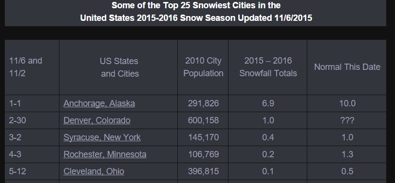
Here it November 6th and we finally have a Top 5 list for the snowiest Big cities in the nation. The current list would have been from the end of the day on the 5th for most of the cities in the Golden Snow Globe contest.

Anchorage, Alaska continues to add to their lead and added another inch of snow since the last update. It seems like Anchorage either gets quite a bit of snow or next to nothing each season. Anchorage did win the snow contest back in the 2011 – 2012 snow season with 134.5 inches of snow.

Snowiest US Cities with Snow

Denver, Colorado slipped past Syracuse, New York picking up an inch of snow since the last update. That was the measurable snow for Denver this season. Syracuse is stuck at 0.4 inches right now and I’m sure that the temperatures being in the 70′s in the northeast has something to do with that. Record temps have been set the last few days for several cities in the northeast and I’m guessing they are in no hurry to stop breaking them.

Rochester, Minnesota remains in 4th place at 0.2 inches and the other newcomer to receive snow this season besides Denver is Cleveland, Ohio which is showing 0.1 inches so far for the 2015 – 2016 snow season. Welcome to the new snow season Denver and Cleveland. Cleveland’s snow may be an adjustment or an error because they weren’t showing snow as of the last update so that may change.

Golden Snow Globe Cities Below Average Snow

Almost all of the cities in the National Golden Snow Globe contest are below their average snowfall for this date, but I don’t expect that to last much longer. Remember, the National snow contest is for cities with a population of 100,000 or more as of the 2010 census. If you know of a Big city that we may be missing that has snow already this season then feel free to add a comment to this post and let me know ;)

Feel free to join our snow group on Facebook. It’s a fun group of men and women of all ages, both snow lovers and haters from all over the country. CLICK HERE to JOIN OUR SNOW GROUP!

Stay Tuned and have an Awesome day everyone!

Congrats to Syracuse, New York on being the second Big city with a population of 100,000 or more to get some snow for the new 2015 – 2016 snow season. Anchorage, Alaska started off this season’s snow contest a little while back picking up 2.8 inches of snow.

Syracuse, NY is reporting 0.4 inches for yesterday, 10/18 and although it isn’t a lot of snow it is enough to move them into second place in the Golden Snow Globe contest. A few smaller towns not too far from Syracuse received up to 9 inches of snow.

With the cold in the air, there were a lot of snowflakes falling, but so far Syracuse is the only city to report measurable snow in the last couple of days. If you know or hear of any other cities with a population of 100,000 or more please leave a comment here to let us know and Thanks ;)

So after the last couple of days with the cold air that blew into the north and northeast we now have a bunch of cities that have received some snowflake to give them a trace of snow. 18 of the Golden Snow Globe cities are reporting at least a trace of snow. We are off to a good start and I have a feeling it’s going to be a fun snow contest once again this season :)

Stay Tuned and Have an Awesome Day Everyone!